Solar Park Site Suitability Analysis: A Multi-Criteria Evaluation in Scotland
🛠 Skills & Tools: ArcGIS Pro Multi-Criteria Evaluation (MCE) Spatial Analysis Suitability Modelling Renewable Energy
Scotland’s rugged terrain and strict land-use regulations present unique challenges for renewable energy developers. The objective was to identify optimal locations that balance solar efficiency, infrastructure logistics and environmental preservation, rather than simply finding ’empty land'.
As a GIS Analyst, I was responsible for developing a data-driven model to identify the most commercially and environmentally viable sites for a new solar park across the entire region.
The Multi-Criteria Evaluation (MCE)
To solve this spatial problem, I used ArcGIS Pro to create a weighted suitability model. This involved processing different datasets into a unified scoring system.
The analysis was driven by four critical spatial constraints:
- Solar Efficiency (Aspect): south-facing slopes were prioritised to maximise solar insolation and energy generation potential.
- Land preservation (constraint): applied a Boolean mask to strictly exclude prime agricultural land, ensuring the project does not conflict with food security.
- Logistical viability: calculated Euclidean Distance to roads and built-up areas. Sites needed to be accessible for construction (close to infrastructure) but not intrusive to residential zones.
- Topography (slope & elevation): filtered for low elevation and flat terrain to minimise construction costs and engineering challenges.
Result & Visualisation
These complex variables were synthesised into a single, easy-to-interpret visual output by performing a Weighted Overlay analysis.
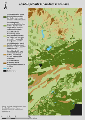
The map below is the result of this spatial analysis. The resulting suitability surface transforms abstract data into a clear ranking system, with black areas indicating prime locations that meet all logistical and environmental criteria.
Impact
This workflow demonstrates a scalable solution for renewable energy planning. Automating the screening process enables stakeholders to:
- Reduce Risk by avoiding the purchase of land with hidden environmental or topographic constraints.
- Save time by instantly narrowing down thousands of square miles to a few dozen viable sites.
- Support decision-making by providing quantitative evidence for planning applications and investment committees.